Sunday, 26 April 2015

Back to Kathmandu, 33 years later: earthquake in Nepal

What happened ?

On Saturday, April 25, 2015, a 7.8-magnitude earthquake struck Nepal just before noon local time. Nearly two dozen aftershocks followed.
The epicenter of the earthquake was located halfway between Kathmandu and Pokhara.


150425 earthquake in Nepal (earthquake.usgs.gov)

Officials in Nepal reported on Sunday that over 2 500 people were killed - at least 800 in Kathmandu alone - and more than 4 300 were hurt, and this estimation is expected to rise.
Update on April 29: more than 5000 people are confirmed dead and more than 6500 injured.

At that time, numerous countries and non governmental organizations around the world  are mobilized to provide aid and supplies.


How to help ?

Here are some major organizations with their online donation link:
- Nepal Red Cross Society: a direct way to help nepalese people (server may be slow or even down).
- Unicef: Children’s Rights & Emergency Relief Organization
- CARE: a leading humanitarian organization that has worked in Nepal since 1978.
- a very complete list of links concerning How to Help the Relief Effort in Nepal is maintained by the NY Times.


French links:
- Architectes de l'urgence: help to rebuild
- Secouristes Sans Frontières
- Fondation de France: Solidarité Nepal


Destructions

Dozens of temples and historical buildings in Kathmandu, Patan and Bhaktapur have collapsed or damaged. The earthquake has destroyed iconic UNESCO heritage sites, causing a major loss for the World Heritage and a long-term threatening for the nepalese touristic attractivity.


in Kathmandu

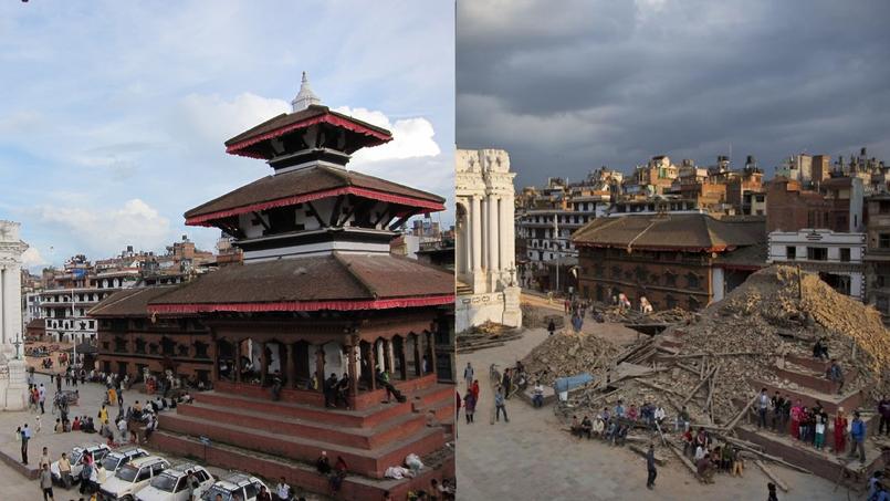
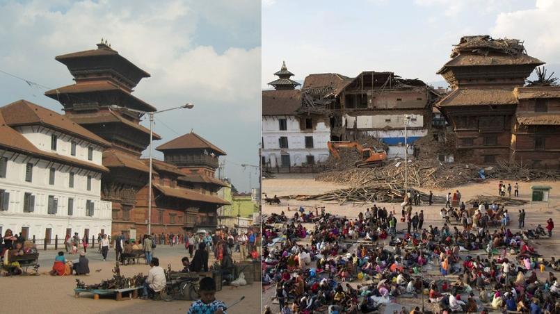
Basantapur Durbar Square is the historical plaza in front of the old royal palace and belongs to the UNESCO World Heritage Sites: see Wikipedia.
> April 2015 Nepal earthquake: Basantapur Durbar Square

According to The Nation, several temples were demolished by the earthquake:
- Kasthamandap temple
- Panchtale temple
- Basantapur Durbar
- Dasa Avtar temple
- Krishna Mandir
A few other monuments, including the Kumari Temple and the Taleju Bhawani, have partially collapsed. 


In the middle, Shiva Parvati temple (source: Narendra Shrestha)
Satellite View by Google Earth
List and map of monuments in Durbar Square


Before / After
(AP Photo/ Niranjan Shrestha et photo de droit commun. Montage: Le Figaro)
Before / After
(AP Photo/ Niranjan Shrestha et photo de droit commun. Montage: Le Figaro)

in Swayambhunath

> April 2015 Nepal earthquake: Swayambhunath
Located west of Kathmandu city, it is a religious complex atop a hill. It is a sacred Buddhist pilgrimage site, featuring a famous stupa with eyes of Buddha looking in all four directions: see Wikipedia.


Dharahara Tower: also known as Bhimsen Tower, it was a 62 metre-tall (203.0 ft) tower: see Wikipedia.


Before / After
Dharahara Tower (Bhimsen Tower)

in Patan (Lalitpur)

Located south of Kathmandu, Patan Durbar Square is one of the three Durbar Squares in the Valley and also belongs to the UNESCO World Heritage Sites: see Wikipedia.
According to India.com, the historic area has been shattered completely.
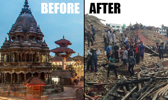
Before / After
Patan Durbar Square devastated

in Bhaktapur

> April 2015 Nepal earthquake: Bhaktapur
Located 13 km east of Kathmandu, Bhaktapur Durbar Square is the third of the three Durbar Squares in the Valley and belongs to the UNESCO World Heritage Sites: see Wikipedia.


Bhaktapur Durbar Square (Omar Havana/Getty Images)


in the Langtang Valley

The Langtang Valley is located 80 km north of Kathmandu.
The earthquake has caused major damages in the Langtang valley: several hundred people were killed, 90% of the district's houses were damaged and the roadways were partially blocked making access difficult for the rescue operations.

Before/After Nepal earthquake: the Langtang Village (satellite view)


In April 1982, 33 years ago, I traveled to Nepal.

I feel very concerned by this tragic event because I visited much of the places that have been struck: Kathmandu, Pashupatinath, Bodnath, Pagan, Bhaktapur and the Langtang valley.

This page is an homage dedicated to the nepalese people and to its cultural heritage.
Here are some links to the pages of my diary including maps and pictures:

- before earthquake: pictures of Nepal in 1982

- Kathmandu: Basantapur Durbar Square

- Kathmandu: Pashupatinath and Bodnath

- Kathmandu Swayambhunath

- Patan (Lalitpur) Durbar Square


Tuesday, 14 October 2014

J004 - Back to New Delhi, 33 years later...using Google's Street View Trekker : Humayun's Tomb, Qutb Minar, Rajpath

New Delhi : Humayun's Tomb, Qutb Minar, Rajpath

October 14, 1981: being in India for four days and already sick...
> read the article (in french)

33 years later, virtual comeback on these three places, using Google's Street View Trekker. Exploring traces of the past with today tools.

_____________________Daily map_____________________


Lucky strike: the three monuments I visited that day in New Delhi belong to the few places in India already filmed by the Google's Street View Trekker.


Direction Nizamuddin West to explore Humayun's Tomb.
The trekker has crossed through the place thoroughly.


The course of the trekker through the Gardens of Humayun's Tomb, Delhi

The Isa Khan tomb complex is located at the right of the entrance.

Entrance from the north door, overlooking the tomb of Isa Khan Niyazi, Delhi

The heavy wooden door is still there, easy to recognize.
The lobed arch, which was crumbling, is now redone. As well as the low wall surrounding the mausoleum. The shrub hedge is gone, and the sparse grass gave way to a beautiful English turf.
Critical problem for the trekker: his point of vue is significantly higher than that of the average human eye. The natural perspective is skewed, and the use of a wide angle lens make it worse.
> visit Isa Khan Niyazi with Google Trekker


North gate, Isa Khan Niyazi tomb, Delhi

The north gate has been seriously restored and palm trees grew well. On the ground, the shadow of the trekker's camera is visible...

Continuation of the visit.

Once the last portal crossed, Humayun's Tomb is fully revealed, covered by a huge white dome.


Humayun's Tomb, Delhi
The trekker's camera leans slightly to the left. The morning sun backlighting the building is already fading colors...

A climb on the terrace.


Domes of Nila Gumbad and Nai-ka-Gumbad, Humayun's tomb, Delhi

Also here, the palm trees that mask the domes appear to have grown well. And, as at the time, the blazing sun does not encourage you to linger...
> visit the terrace with Google Trekker

Once again, rickshaw to reach Qutb Minar.

It's not easy to find a similar point of view: the narrow framing of my photo reveals only few clues. One has to grope with satellite images, and explore the paths and views of the trekker.


Quwwat-ul-Islam Mosque and Qutb Minar, Delhi

To the left in the photo, one can see visitors on the first balcony.
On December 4, 1981, a blackout unleashed a dreadful panic in the tower causing 45 victims, mainly schoolchildren. Since then, access to the first floor is prohibited.
This tragedy, so close after my own visit, has become inseparable from this place.

On the ground, the trekker's lens is facing the sun...
> visit Qutb Minar with Google Trekker

Way back through Raj Path that connects India Gate to the presidential palace Rashtrapati Bhavan.


Jaipur Column et Rashtrapati Bhavan, Rajpath, Delhi
Silhouettes.
1981: crossing of beautiful bell-bottoms.
2013: access to the presidential palace is blocked by yellow plastic barriers ...


From Rashtrapati Bhavan: India Gate, Rajpath, Delhi
> visit Raj Path, courtesy of Pious Saraswat


Did you visit and shoot this places ? What was YOUR point of view ?
English readers, please help me to improve this version.
Swim in India


Sunday, 12 October 2014

Back at Red Fort, Delhi: 33 years later...with Google Street View Trekker

Delhi, Red Fort


October 12, 1981: first day of sightseeing, introducing the magnificient Red Fort complex.
> read the article (in french)

Retro-blogging tips: in order to geolocate each photo slide, I have investigated in different ways and used:
- narrations from my diaries ;
- descriptions from my old touristic guides ;
- street and relief maps, satellite views, mainly from Google Maps ;
- similar pictures, already geolocated on Panoramio or Flickr ;
- various websites and blogs describing the same place.

Eventually, shadows on the picture help me to confirm the point of view, and it's orientation on a north-south axis, according to the estimated hour of the shooting.

It's great when I can compare my pictures and their GPS coordinates with those of a famous geographic information system, for example: Google.
Looking at the same direction, but 33 years later.
What kind of picture is proposed ? What has changed ?

In 2014, the Red Fort is one of the few places in India that has already been filmed by the Google Street View Trekker.
(trekker : a human carrying a backpack supporting a 360° camera and catching a bunch of datas. On Google Maps, the trekker point of vue is accessed by clicking the little yellow man icon.)


Check out these before & after pictures: India in 1981, shot on Kodachrome 64 Film. India in 2013, shot by a cyber visitor.


Lahori Gate, Red Fort, Delhi

Throne, Diwan-i Aam, Red Fort, Delhi

Naqqar Khana, Red Fort, Delhi

Diwan-i-Khas & Moti Masjid & Hammans, Khas-Mahal, Red Fort, Delhi

Inside Tasbih-Khana and Rang Mahal, Khas-Mahal, Red Fort, Delhi


> the French version of this article


Tuesday, 29 April 2014

How I met Amitabh Bachchan and Zeenat Aman in Bhaktapur

Thursday, April 29, 1982 

I had been traveling in India by myself for already 6 months before entering to Nepal.
On a visit to Bhaktapur, an ancient Newar town located eight miles from Kathmandu, I encountered a huge crowd gathered on Durbar Square.
A movie team from Bollywood was there, with directors, assistants, lightings and a camera dolly on rails.
I easily recognized the famous Amitabh Bachchan, dressed in a black leather jacket and wearing white trousers.
He was performing a dance scene with a beautiful actress clothed in a yellow robe.
Step by step, they played the script of the whole scene while music was playing loudly...
Click here if you want to see on a map the accurate location where it took place.


April 2014

It took me a while to identify the filming that I had attended.
I searched in Amitabh's filmography and last Saturday, I finally found it.
32 years later, thanks to Internet, I could see the clip for the very first time.

It is named "Pyar Mein Dil Pe Maar De Goli", from the film "Mahaan".
The actress is Zeenat Aman, a famous and glamourous Bollywood star.
A good quality clip may be seen on Youtube.
I like the song and the acting, it's quite fun and kitch.

I'm pleased to publish some previously unreleased pictures of this event. Feel free to share and to mention this article...
> Read the full story (in french)


Namaste


Amitabh Bachchan on Durbar Square, with Nyatapola Pagoda, Bhaktapur, Nepal 
Actors in action : Zeenat Aman and Amitabh Bachchan, Durbar Square, Bhaktapur, Nepal
A litte rest for Zeenat Aman and Amitabh Bachchan, in the shade of the Stone Lions, Durbar Square, Bhaktapur, Nepal


Update: April 2015

On April 25, 2015, around noon local time, a 7.8-magnitude earthquake struck Nepal just before noon local time: 4 000 people were killed and more than 7 500 were hurt.
Dozens of temples and historical buildings in Kathmandu, Patan and Bhaktapur have collapsed or damaged (> see details here).

Some media have reported the fact that Amitabh Bachchan and Zeenat Aman had been acting on Durbar Square 33 years ago:

But the shooting for the film "Mahaan" happened in Bakhtapur Durbar Square and not in Kathmandu Durbar Square.


Wednesday, 4 December 2013

A blog concerning "retro-blogging"...


This blog aims to share insights and opinions about "retro-blogging".What is "retro-blogging" ?
One definition could be : using current paradigms and technologies (blogs, photo tagging, augmented reality,...) to relate past events or stories and publish them on the Internet.
Hmmm...

I'll relate the tasks I met to put on line a 7 months trip that occurred in India and Nepal a few decades ago :
- using material sources : diary or travelogue, maps, Kodachrome slides, documents,...
- digitalization, corrections, documentation and tagging
- publishing : tools and web sites, results
- interaction with Internet users


Project genesis

Mid-2013...My last job has ended. I'm free to spend a few months on my favorite research subject : how to tell an interactive story and to propose an interesting navigation and interface to the user ?
I'm also curious about using social media to "feed the Web" and to observe its impacts : indexation by robots and user feedbacks.


Which content ?

I have a content at my disposal that I may use and manage : 3 diaries, 440 photo slides, 50 sketches, brought back from my initiatory journey in India.

After much hesitation, I decided to use this matter to propose an interactive content, structured by themes, dates and GPS geolocation.
It is also expected that this content will interact with related subjects or views already available on the Internet.

Last but not least, Mother India is an astonishing country and a trip over there can never be forgotten...


Starting point

"Swim in India" relates a journey into India and Nepal, back in a time with no mobile phone, digital camera, Internet cafes or GPS guidance.
The date of launching is the 10th of October, anniversary of my departure many years before. So I am compelled to publish a new entry on a daily basis.


First steps

On-line publishing will occur on various websites :

- 1 blog in french : http://swim-in-india.blogspot.fr/
- 3 photo-sharing websites : Flickr photos, Flickr sketches and Panoramio  
- 2 Twitter accounts : english and french 
- 1 Facebook account
- and a few more french websites and forums based on sharing travel experience.


Rules

In order to exploit the chronological functions of blog publishing, a new entry will be added every day, respecting the real-time condition of the journey...with just a few decades delay.


To be followed...

You are invited to enter your e-mail address in the field below to subscribe to this blog and receive the latest news.

Your participation is greatly expected to share experiences and tips about publishing contents that are meta-tagged with time and location.